
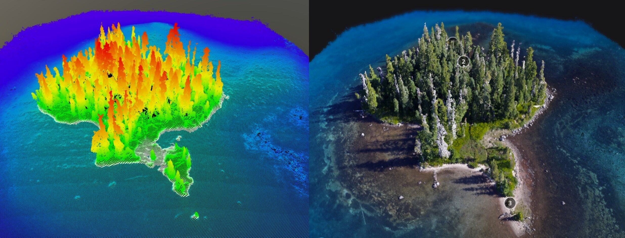
3D Story Map
3D Story Mapping creates a Digital Twin of your site and delivers it in a customizable, interactive 3D viewing experience to bring your site to all stakeholders, even those at a distance.
Combining several aerial imagery techniques and products, a Digital Twin is a geographically accurate representation of your site to help you more easily track, predict, decide, and share your impact.
Bring your site to supporters
Seamlessly bridge the gap between your site's physical accessibility and your supporters and partners. Utilizing state-of-the-art 'Structure from Motion' processing, we transform your site into a lifelike digital 3D replica.
Deliverables
✔︎ Embedded 3D Story Map with custom annotations.
✔︎ Hosting provided
✔︎ Copy and paste a small bit of code into your website to start sharing your digital twin with stakeholders.
What Our Partners Say
Our Work Process
1
Start with the Aerial Topo Mapping service.
2
Then we work together to annotate and embed your digital twin.
Applications
See our comprehensive list of applications for 3D story map and aerial imagery.
-
Repeat 3D Story Maps can help highlight restoration changes for all stakeholders, even those at a distance.
-
Attention spans are shorter than ever, and consumers are demanding more immersive and interactive experiences to stay engaged. 3D Story Maps bring your sites to the public on desktop, mobile, or VR headset.
-
Imagine how your brainstorming sessions may change if your whole team can see every tree, every river bend, every ditch in 3D, from a birds-eye-perspective. Save time, money, and fuel, and skip the next site visit.
-
It's hard to get everyone on a zoom call at the same time, let alone a site visit. Get everyone on the same page with a 3D Story Map.
FAQs
-
3D Story Mapping is a service that creates a Digital Twin of your site and delivers it in a customizable, interactive 3D viewing experience. This allows you to bring your site to all stakeholders, even those at a distance.
-
A Digital Twin in the context of 3D Story Mapping is a geographically accurate, three-dimensional representation of a site or landscape. It's created using various aerial imagery techniques, offering a detailed digital representation of the location.
-
There are many benefits to using 3D Story Mapping, including:
Improved communication and collaboration: 3D Story Maps can help you to better communicate and collaborate with stakeholders by providing a shared visual understanding of your site.
Increased efficiency: 3D Story Maps can help you to identify and address potential issues more quickly and efficiently.
Reduced costs: 3D Story Maps can help you to save money by reducing the need for site visits and physical surveys.
Enhanced decision-making: 3D Story Maps can help you to make more informed decisions about your site by providing you with a holistic view of all relevant data that your entire team can access.
-
3D Story Mapping can be used for a variety of applications, including:
Site planning and design: 3D Story Maps can be used to help plan and design new restoration projects.
Construction monitoring: 3D Story Maps can be used to monitor construction progress and identify potential problems.
Environmental monitoring: 3D Story Maps can be used to monitor environmental changes over time.
Asset management: 3D Story Maps can be used to manage and track the location and condition of assets.
Public engagement: 3D Story Maps can be used to engage and educate the public about the impacts of your work.
-
We combine several aerial imagery techniques, including photogrammetry and/or LiDAR, to capture high-resolution images and data of the site. These are then processed to create an accurate 3D model.
-
This service is valuable for urban planners, environmentalists, construction companies, land developers, educational institutions, and any organization needing to showcase or analyze a physical site in detail.
-
It enables stakeholders to virtually visit and explore a site, aiding in tracking developments, predicting outcomes, making informed decisions, and sharing impacts with others, regardless of their location.
-
Yes, the Digital Twin can be enriched with additional data layers, such as demographic information, environmental data, or infrastructure details, to provide a more comprehensive understanding of the site.
-
Absolutely, users can navigate through the 3D environment, zoom in on specific areas, and interact with various elements of the model for an in-depth understanding of the site.
-
The 3D Story Map is typically accessible via web browsers, requiring no special software for basic viewing. For more advanced interactions, specific software or apps may be recommended.
-
We strive for high accuracy in our models by using precise aerial imagery techniques. The level of detail and accuracy depends on the specific requirements of the project.
-
By providing a realistic and detailed view of the site, it helps in project visualization, planning, and monitoring, enhancing communication and decision-making processes.
Other Services
-
![]()
360° Virtual Tours
Give your audience an experience. Engage the next generation of followers
-
![]()
Aerial Mapping
Monitor better with a high-res photo map of your site. Chronicle your site and measure changes over time.
-
![]()
Aerial Topo Mapping
Analyze your site in three dimensions for better stewardship Bring your site to supporters with a digital 3D Story Map
-
![]()
Photo-Point Monitoring
Tell the story of seasonal and restoration changes on a landscape scale
-
![]()
Aerial Photo & Video
Tell the story of your work with rich and eye-catching visuals from above
-
![]()
GIS Analysis
Turn raw aerial data into actionable insights. Answer research questions and report to stakeholders.
-
![]()
Drone Training
Build drone capacity in-house. We develop custom curricula tailored to your organization and team needs.



Interested in 3D story map?
Stay informed with the latest updates! Learn how Foresight Drones is collaborating with local organizations to positively influence the Pacific Northwest ecology.